Deviation Surveys
A deviation survey stores values of True Vertical Depth (TVD) for a well. This data can be used to re-calibrate the vertical scale of a well on a chart. This is useful when comparing wells which are not drilled vertically, as depths can be compared like-for-like. Additionally, data from a deviation survey will plot the course of the well bore on the TVD/Offset chart. The latter is particularly useful for 'horizontal' well monitoring or biosteering.
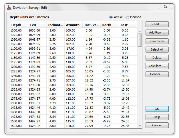
Deviation Survey dialog
Open this dialog by selecting the desired Well in the Wells & Outcrops module, and pressing the Dev. Surv button.
Each well may store two deviation surveys. Toggle the view between them using the using the radio buttons at the top of this dialog. Usually the Actual survey is used. The Planned (secondary) deviation survey is for use in biosteering, for plotting a proposed lateral path on the TVD/Offset Chart.
Note: if the Planned and Actual radio buttons appear disabled on this dialog, you will need to update your database before you can use the secondary survey feature. Please contact StrataData if you require this update.
You may import (read) a TVD survey file or enter data depth-by-depth.
Reading values from a file
Deviation survey files are usually readily available as part of the logging suite.
-
Press Read to open an Input dialog.
Note: You will be warned that all current entries will be cleared.
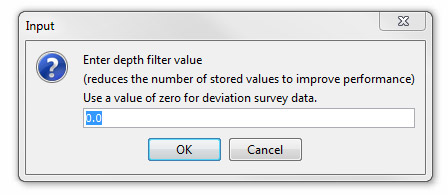
Enter a value to filter the data in the file to be read. This will speed the process of importing by reducing the number of data points.
Hint: If the values in a deviation file are given in typical log increments of 0.5', a filter value of 10 is recommended as this will reduce the size of the dataset without significantly affecting the quality of the data. If your data file has fewer data points, then use a filter value of 0.0 (default value).
-
Next select the deviation file from a standard file selector. The contents of the data file will be read and displayed in the Deviation Survey File Parameters dialog.
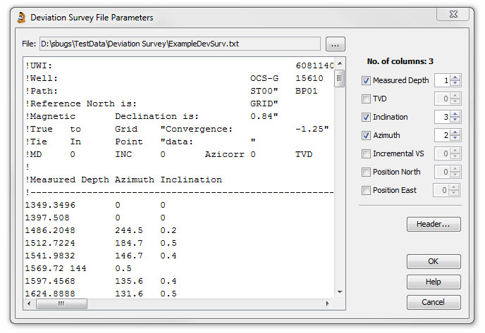
Note: Many files display TVD as TVDSS files (True Vertical Depth Sub Sea) and include a correction for Rotary Table Elevation (RTE) as well as for deviation. It is therefore important when comparing wells in a correlation diagram that have been converted to TVD, that they share a common reference point.
Because the configuration of deviation files is variable you must inform StrataBugs how to read the data file correctly. On the righthand side of the dialog are a number of checkboxes. Select these in order of the columns of data displayed on the left. The spinners on the far right will reflect your selection by assign a number to each column. You can correct any mistakes by incrementing or decrementing the spinner for a particular column.
The available columns and their definitions are:
Measured Depth - The drilled depth
TVD - the depth of the drill bit below a depth datum (usually either rotary table or sea sea level)
Inclination - deviation from the vertical in degrees
Azimuth - degrees from North
Incremental VS - the vertical distance by which the well bore is incremented between samples in a well.
Position North - position North relative to spud location
Position East - position East relative to spud location
- You can also pull out header information from the file. Select any text from the data file display (highlight then Ctrl + C) then press the Header button. This will open the Deviation Survey Header dialog and display the selected text which may be edited.
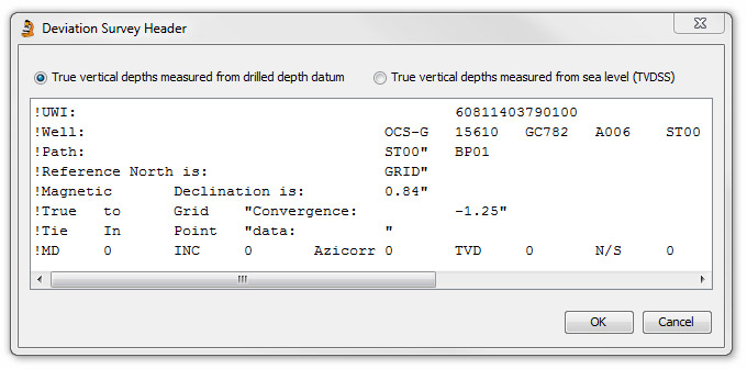
Select one of the option buttons at the top of the dialog to indicate if the TVD is measured from the drilled depth datum or from Sea Level (TVDSS).
To view the saved header information at another time, open the Deviation survey : Edit dialog and press the Header... button.
- OK the Parameters dialog to bring you back to the main dialog, with your data. To calculate the data in empty fields, press the Calculate button to open the Deviation Survey Calculation dialog.
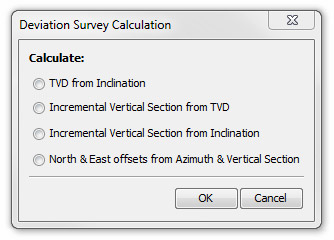
Select which calculations you need to do in order to derive the TVD, Incremental Vertical Section and North & East Offsets from the other available data. The Incremental Vertical Section can be derived from either the TVD or the Inclination (preferred as it gives a better match to driller's data). This process can be repeated if several columns of data are missing. Press OK to return to the main dialog where the newly calculated data will be displayed.
You can now display the offset of the well bore in Samples (Charts tab).
Entering data manually
You may enter data row-by-row using this dialog.
Hint: To do this for a deviation survey would be impractical, but TVD can be entered for critical depths if the full survey is not available.
To add TVD depth equivalents one at a time use the Add Rows or Insert Row buttons.
Add Rows opens an input dialog into which you enter the number of rows of data you want to add. Press OK. Enter the Drilled depths in the lefthand (Depth) column and the equivalent TVD in the righthand column.
Insert row enables you to insert a new pair of values in a row above the one selected on the list.
To remove a row from the list, first select it then press Remove.
To remove all the data, press Select All and then press Remove.
Hint: This method is only appropriate if you do not have a TVD file to read and you just want to add a few critical depths to roughly calibrate the drilled depths with the TVD.
Page last updated: 25-Nov-2014 12:02