Interval (Chrono/Lithostratigraphy and Biozone): Add/Edit dialogs
The dialogs for adding and editing intervals for Chronostratigraphy, Lithostratigraphy and Biozones are essentially the same and are here described together. These dialogs enable you to add (or edit) an interval to a well and assign to it a unit from a particular scheme. This example is for a biozone interval.
Note: you can also open this dialog by double-clicking on an interval in any chart on the Samples & Interpretations Charts tab.
Samples |
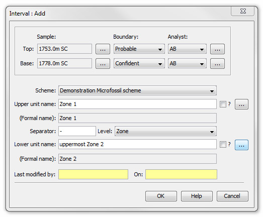
Select the Top and Base Sample which define the interval by pressing the ellipsis (...) buttons to the right of the Sample fields to open the Sample: Select dialog.
|
Boundaries |
Select a type for the Top and Base Boundaries by making a selection from the drop down lists attached to the Boundary fields. The options are Confident, Probable, Possible, Unconformable, ?Unconformable, Fault, ?Fault or Reverse fault Note: The boundary type is illustrated on charts by different line styles, and forms the basis of the style of correlations lines which inherit the style from intervals through which they pass. |
Analyst |
To show who made the interpretation of each boundary select an Analyst from the drop down lists attached to the Analyst fields. These will display all the analysts who have contributed data to the current well. The analyst selection is only enabled for Biozone intervals, since the biostratigraphy may be determined by the sample analyses. If there are no analytical data for the well, you will need to select the analyst from the list of all the analysts in the database. To do this press the ellipsis (...) buttons to the right of the Analyst fields and select an analyst from the list in the Select Analyst dialog. |
Scheme |
Select a Stratigraphic Scheme from the drop down list attached to the Scheme field. Every interval MUST be linked to a scheme name (unlike in previous versions of StrataBugs). For biozone intervals, you may have data for more than one scheme which covers the same depth interval. For chronostratigraphic and lithostratigraphic intervals, you must not have any overlapping intervals within any version, regardless of scheme. |
Unit names |
Select the Upper unit name for this interval by pressing the ellipsis (...) button to the right of the Upper unit name field. A list of units from the selected scheme are displayed in the Select Unit dialog. The Lower unit name field is used to indicate that the selected interval spans more than one stratigraphic unit, and that the boundaries between them cannot be identified (e.g. Paleocene - Eocene). Repeat the process described above ensuring that the oldest unit is always in this field. If there is no lower unit name leave this field blank. Use the check boxes adjacent to the Upper/Lower unit name fields to prefix the unit name with a "?" if required.
The Separator will automatically display between the two unit names. By default the separator is a '-' but you can edit it to any string up to ten characters in length. Note that characters used do have implications and you should try to use them consistently throughout your database. For example, '-' implies the interval goes FROM the upper unit TO the lower unit, while '/' implies that the interval could represent EITHER the upper OR the lower unit. The Level field will automatically display the hierarchical level of the selected units. If you have not selected a unit from a scheme and wish only to type in an informal term you must then select the desired level from the drop down list attached to the Level field.
|
Page last updated: 01-Dec-2014 15:52