| << Previous | Learning Trail | Contents | Section 5: Schemes | Next >> |
| StrataBugs Learning Trail | Section 5: Schemes |
Working with schemes
When you make interpretations in StrataBugs, you will generally reference an item or 'unit' from a scheme, which is defined separately. Referencing standard schemes in this way makes your data more consistent and comparable, and means you can correlate interpretations between wells. Before you begin to add interpretations to wells you should create schemes for all types of geological data. Each scheme need only be entered once into the scheme dictionary. Some schemes are available as part of the StrataBugs database or available to download from the StrataData website.
Note: It is possible to (partially) omit this procedure (i.e. not to create Schemes) but this will result in all interval names being informal terms. This will prevent you from drawing correlation lines or using depth/age plots at a later stage.
There are three types of geological scheme in StrataBugs: stratigraphic, palaeoenvironment and lithology.
Stratigraphic scheme
 A hierarchical grouping of stratigraphic units which are related to each other stratigraphically. Ages are assigned to the unit boundaries; this helps to define the relationships between units. In wells you can pick 'intervals' which are assigned a unit from a scheme. Units belonging to a scheme can be correlated from well to well using these intervals. The age of an interval is implied by its unit and this can be helpful for depth/age plots. If you do not set the unit ages it will not be possible to plot the scheme.
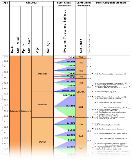
Chronostratigraphy, Lithostratigraphy, Biozones, Sequences and Composite Standards are all stratigraphic schemes. Sequence schemes have a list of surfaces (with ages) as well as units, and composite standards are 'event schemes' which consist of events with ages.
From v2.1 onwards all stratigraphic schemes must be explicitly linked to a timescale (chronostratigraphic framework).
To create a stratigraphic scheme in the Schemes & Interpretations module:
-
From the menu bar, select Schemes | Stratigraphic Schemes to open the Stratigraphic Schemes Internal Frame. In this frame, set the type to the type of scheme you want to add.
-
Press Add... and you will see the Stratigraphic Scheme dialog (or, if you are adding a new Composite Standard, the Composite Standard dialog). Enter a name for the new scheme and then add units.
Palaeoenvironment scheme
A scheme representing an ordered range of palaeoenvironments. These may reflect water depth, climate, distance from shoreline, different depositional settings such as found in carbonate realm or non-marine habitats. They are not implicitly restricted stratigraphically and therefore do not have ages associated with their boundaries. For this reason they are considered separately from Stratigraphic schemes.
To create a palaeoenvironment scheme:
From the menu bar, select Schemes | Palaeoenvironment schemes to open the Palaeoenvironment Schemes Internal Frame.
-
Press Add... in this frame to open the Palaeoenvironment Scheme dialog. Enter a name for the scheme and add units.
See also: Working with Palaeoenvironments
Lithology scheme
The lithology scheme is graphical picklist of lithotypes. Lithotypes are not related stratigraphically to each other and do not imply age. There is a single lithology scheme common to all StrataBugs users. This is to ensure that all users use the same graphic symbols to represent the same lithotypes so that irregularities do no occur when lithological data are exchanged. The scheme can be updated on request and StrataData will make the revised scheme available to all users.
To view the lithology scheme, select from the menu bar Schemes | Lithology | Description and grainsize to open the Lithologies dialog, where you can edit some attributes of the scheme.
The lithology scheme is used for adding interval lithology and sample lithology data. To add lithology intervals, select the well in the Wells & Outcrops module and press Lithology... (opens the Interval Lithology dialog). To add lithology to a sample, select the sample in the Samples & Interpretations module and double-click in its Lithology column (opens the Sample Lithology dialog).

Page last updated: 05-Dec-2014 9:41