Month: April 2016
Sample Depth Precision
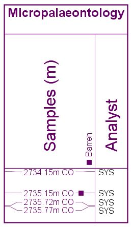
Possibly the most frequently asked question we are asked is “why do my samples show with different numbers of decimal places?”, or “where are the decimal places on my cuttings?”. StrataBugs charts have always displayed the different sample types with precision which reflects the nature of the sampling. Cuttings samples show to the nearest whole metre (or foot) because it would be misleading to suggest the depth was any more precise than that.
Here’s the full information for all sample types:
| CU | cutting | nearest whole metre or foot |
| SC | sidewall core | 1 decimal place |
| CO | core | 2 decimal places |
| OC | outcrop | 2 decimal places |
| LOG | log pick | 1, 2 or 3dp – configurable by super-user (Control Panel > Config > Default samples depths) |
This affects the charts and wherever samples are displayed along with their type and label in the data tables. The position of samples is still determined by the depth you give them (and which, in the case of cores (and optionally cuttings) may be affected by core shifting).
These levels of precision follow an industry convention used since version 1.0 of StrataBugs. One drawback is sometimes where you have a well originally drilled in feet and now dislayed in metres, where you would like to show the cuttings depths to 2 decimal places to reflect the converted number. You can do this in the Samples panel by checking off the “Display symbols” option in the panel propeties.
Within the database itself, all sample depths are stored in metres to at least three decimal places (dependent on the database type).
When is an analysis barren?
Analyses may be ‘prepared’ (yet to be analysed), ‘analysed’ (contains occurrences), or ‘barren‘ – indicating that they have been analysed but found to contain no taxa.
When we reviewed and tightened up all aspects of the way the biostrat data were stored in v2.0, it seemed sensible to enforce that analyses marked as barren did not contain occurrences of microfossils. Therefore the only option when clicking the barren flag was to clear all the occurrences. It’s been pointed out to us since that analyses can contain accessory minerals or perhaps caved taxa, while still technically being barren of microfossils.
The most recent test update will allow you to have your cake and eat it – you still get the option to clear the occurrence list, but you can have some analysed data while the analysis is marked as barren. This doesn’t require a change to the underlying data model, and any data files exported will reflect what you have on screen. The only caveat is that if somebody without the update imports the file, their analysis will not be barren.